High-Resolution Site Characterization Reduces Risk Through An Adaptive Management Approach
By: CascadeWhenever environmental remediation professionals work on a subsurface cleanup, uncertainty lies everywhere. Risk, however, can be reduced with a better understanding of the conditions below your feet. Kerry Stonestreet, Cascade’s former Data Management and Visualization leader, presented the webinar, “Managing Uncertainty and Adaptive Management.” In Kerry’s presentation, he explained how the process of characterizing complex sites and selecting cleanup remedies is also a process of reducing uncertainty. A key recommendation from the, EPA Superfund Task Force Report, is the implementation of Adaptive Management as a site management tool in expediting cleanup and the remediation of complex sites.
If you missed this presentation, you can still watch the recording at your convenience.
In this blog, Kerry expands on his response to some very insightful questions from the webinar audience.
What is the geologic setting, and how do the USCS classifications relate to the geology? How was the “clay” deposited?
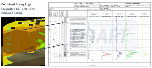
These questions came up while highlighting a practical application of complementary site characterization tools and methods to present these data in a useful way. In this case, two collocated direct push soil borings were completed a few feet apart. First, a Membrane Interface Probe (MIP) boring and the other, a soil boring with soil cores logged by a geologist. These data are presented on the slide shown below. On the left is a 3D view. On the right a combined boring log showing both a standard soil boring log and the five line graphs of data from the MIP boring (EC, ECD, PID, FID, XSD).
Electrical Conductivity (EC) is depicted as the brown to yellow vertical slice with higher conductivity represented with darker colors and typical of fine-grained soils (e.g. clay). The EC response correlates well with the geologist’s observations and resulting Unified Soil Classification Codes (USCS). This is called-out with the double black arrows highlighting the clay unit (CL) and the courser-grained clayey sand (SC) and clayey gravel (GC) materials beneath the clay.
The site was located near a major river and the depositional setting is consistent with alluvial terrace deposits, basal alluvial sands and gravels overlain by finer-grained alluvial clays and silts.
The high resolution of MIP provided data used to create detailed 3D models of the variable thickness basal aquifer, varying from two to twelve feet near the source area. Additionally, a MIP transect located just downgradient of the source area revealed the groundwater plume was confined to a much smaller volume than predicted by previous traditional characterization efforts. An In Situ Chemical Oxidation (ISCO) remedy was implemented with detailed injection volumes tailored to the variable thickness basal aquifer.
Do you think an adaptive management strategy can be approved without a solid CSM?
A robust Conceptual Site Model (CSM) is critical to understanding and communicating vast amounts of data and complex subsurface concepts. It is an integral component of adaptive management strategies promoted in numerous guidance documents, a few possible references included below. It seems unlikely a regulator would approve an adaptive management strategy without a solid CSM to communicate essential elements of the plan.
References:
EPA. 2011. Environmental Cleanup Best Management Practices: Effective Use of the Project Lifecycle Conceptual Site Model. EPA 542-F-11-011. July.
EPA. 2012a. Groundwater Remedy Optimization Progress Report: 2010–2011. OSWER Directive No. 9283.1-38. July.
EPA. 2013b. Superfund Remedy Report, 14th Edition. EPA 542-R-13-016. November. https://www.epa.gov/remedytech/superfund-remedy-report.
National Research Council. 2003. Environmental Cleanup at Navy Facilities: Adaptive Site Management. Washington, DC: The National Academies Press. https://doi.org/10.17226/10599.
National Research Council. 2013. Alternatives for Managing the Nation's Complex Contaminated Groundwater Sites. Washington, DC: The National Academies Press. https://doi.org/10.17226/14668.
What can consultants do who don’t have these capabilities?
Site characterization and remedial technologies generate vast amounts of data. High-Resolution Site Characterization (HRSC) tools such as MIP and other direct sensing technologies generate digital data well suited to rapid analysis and confident decision-making. Turning data into actionable information is best achieved utilizing capable reporting and analysis software such as Earth Visualization Studio (EVS), Geographic Information Systems (GIS) and Relational Database Management Systems (RDBMS). If your organization does not have experienced data management and analysis capabilities talk with us. We know these data and use state of the industry data management and analysis tools (e.g., EVS, ArcGIS, gINT, SQL Server). If needed, we can deliver data in your preferred format (e.g., EQuIS, Scribe).
In the long run, will this add costs to remediation?
Small, less complex sites may not realize a significant benefit with an Adaptive Management strategy. The key premise is acknowledging uncertainty exists with subsurface conditions and processes and planning an iterative approach to incrementally reduce uncertainty. Often reducing uncertainty means additional site characterization to address data gaps. This incurs additional up-front costs but results in an improved CSM and remedial design. Improving the CSM is the number one recommendation in EPA’s Superfund Optimization report at 68%. Inadequate characterization is often cited as the reason a remedy failed or underperformed.
Significant uncertainties can exist throughout the project lifecycle from understanding subsurface conditions through less technical challenges (regulatory requirements, community involvement). These contribute to making a complex site and a candidate for an adaptive management strategy.
Perhaps a better answer is contained in this Albert Einstein quote,
“If I were given one hour to save the planet, I would spend 59 minutes defining the problem and one minute resolving it.”
Join our newsletter

A bimonthly email with the latest expert insights in drilling and remediation