Why You Should Combine Characterization Tools
By: Cascade EnvironmentalA high level of confidence in your site characterization data is needed to develop a successful remediation strategy. Due to variability in subsurface conditions at most sites, however, conventional site characterization approaches can be time-consuming or require effort disproportionate to the scale of the ultimate remediation problem. Often, this is because of the number of boreholes that must be advanced and the multiple tools required. That’s why multi-sensor tools are quickly becoming a popular choice—they reduce the cost and time spent on advancing multiple boreholes, and allow complete data sets to be generated from a single advancement.
In this blog post, we’ll cover the multi-sensor tools that are currently available, how they save time and money, and the ways they can help streamline your site characterization efforts.
WHAT MULTI-SENSOR TOOLS ARE AVAILABLE?
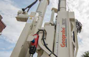
Many multi-sensor technologies have been made commercially available by Geoprobe, including the Membrane Interface Probe (MIP), electrical conductivity probe (EC), Hydraulic Profiling Tool (HPT), Optical Image Profiler (OIP), and OIP-Green. Others, such as the Waterloo Advanced Profiling System (WaterlooAPS)—offered only by Cascade—and laser-induced fluorescence (LIF) technologies can be combined to produce high-resolution characterization data with a minimal number of boreholes, making quality characterization work possible even on small sites.
Tools like the WaterlooAPS/EC and WaterlooAPS/Ultra Violet Optical Screen Tool (UVOST) were originally created for specific situations, but together, they have broad potential for environmental assessment.
HOW DO MULTI-SENSOR TOOLS SAVE TIME AND MONEY?
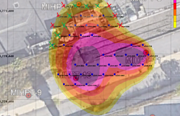
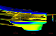
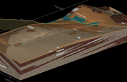
The “stacking” or combination of sensors on a single drill string reduces the overall duration—and therefore cost—of these field data collection efforts. Additionally, it ensures the stacked sensors are collecting vertical data from the exact same horizontal location. With most of these tools, a surrogate for contamination is logged, and the additional sensor is collecting data on the hydrogeologic environment in which the contaminants are present. These data streams, in combination, are critical for the design of an effective remediation strategy.
Historically, remediation programs relied on large-scale hydrogeologic measurements. More recently, we as an industry have come to realize that small-scale heterogeneities control the remedies that are often implemented on sites.
HOW DO MULTI-SENSOR TOOLS STREAMLINE SITE CHARACTERIZATION?
The use of multi-sensor tools eliminates the need for having multiple drill rigs on site. This consequently reduces the need for scheduling and coordination between drilling and field oversight crews, the work footprint, the number of people required on site, and the health and safety issues that arise when you increase the number of tools and crews.
There’s a reason multi-sensor tools are gaining popularity. If you’d like to learn more about how they can benefit your projects, check out our webinar, Getting the Most Information From a Single Borehole Advancement.
You may also be interested in these webinars:
- How to Justify High-Resolution Site Characterization to Your Clients
- How to Design an Efficient HRSC Program Based on Objectives and Data Gaps
An earlier version of this article was in 2019. We've published this update because multi-sensor tools continue to be an important option during site characterization.
Join our newsletter

A bimonthly email with the latest expert insights in drilling and remediation